
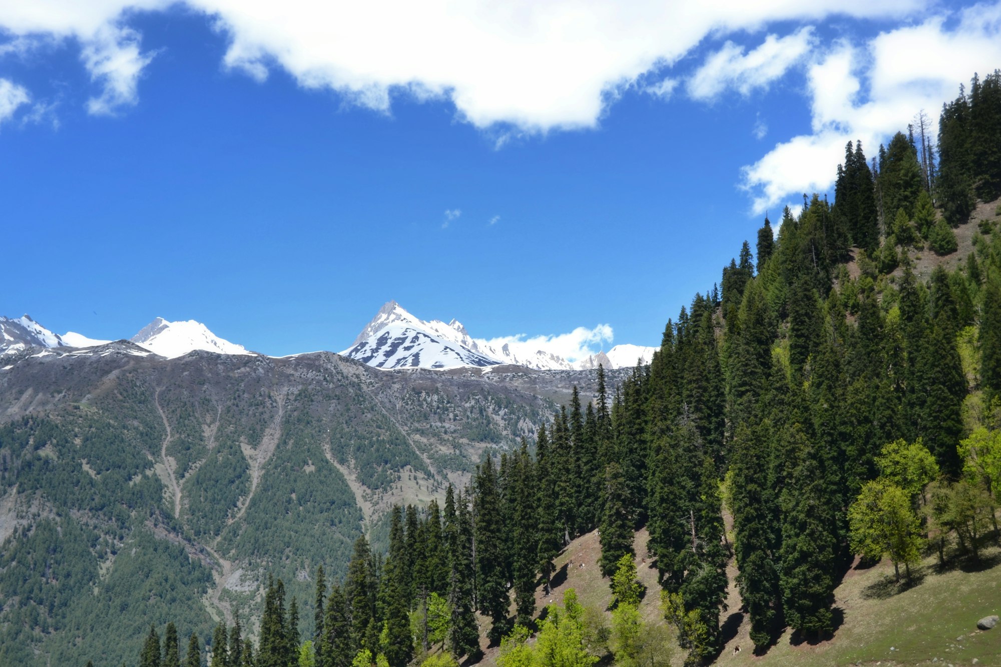
Active situation
Bhutan: glacial flood
Active situation ·Glacial lake outburst flood
●Active situation. Being tracked now. The figures are still moving.Bhutan ·30 Oct 2026
Four readings this page holds, and where each one is explained. Every source behind them.
What is a GLOF
A flood with no rain in it.
Picture a bucket made of ice and loose rubble, parked high on a mountain. The glacier left it there when it melted back, and it has been filling with meltwater ever since. Nobody built it. Nothing holds it but the rubble.
Now global heating — heating, not warming — thins the ice binding that rubble together. The walls were never strong. They are getting weaker.
Then something falls in. A slab of rock. A wall of ice. The bucket empties down the valley all at once, and it does it in minutes.
By the time anyone downstream knows, it is already there.
The numbers we cannot ignore
The geography of this risk is already mapped. What follows is what has been counted, and by whom.
The danger is not a distant hypothetical. The question is whether monitoring, planning and construction follow what is already known.
And they are not separate hazards. This is one chain.
- Warming and glacier retreat
- Unstable ice, rock and slopes; glacial lakes forming and expanding
- A trigger — extreme rain, avalanche, landslide or earthquake
- River blockage, or a lake outburst
- Debris flow and flash flood
- Roads, bridges, hydropower and towns in the path
- Mass casualties, tens of kilometres downstream
Flood, landslide, cloudburst, avalanche, outburst — described one at a time, they look like separate accidents. They are a sequence, and it is why assessment project by project cannot see what arrives catchment by catchment.
What science can say
Climate change does not pull every trigger, but it is loading the system: glaciers retreat, new lakes form and existing ones expand, moraine dams and frozen rock lose their binding, and slopes become less stable. Across the Third Pole, outburst risk is projected to roughly triple by 2100 — with ICIMOD's own caveat that a higher hazard has not yet produced a higher rate of floods.
What has not been attributed
Nobody has established that climate change caused THIS event. Single-event attribution takes months, and for a glacier or rock collapse it is often not possible at all. A rising hazard across a region is not a finding about one flood in it.
All 16 standing figures for this hazard, and their sources
A glacial lake outburst is a flood with no rain in it. Meltwater collects behind a moraine or an ice dam, something displaces it — a rockfall, an avalanche, a thaw — and the dam fails in minutes. The Himalaya holds tens of thousands of these lakes, India monitors a fraction of them, and the warning systems are almost entirely unbuilt.
28,043 — Glacial lakes mapped across the Indian Himalayan river basins. Lakes above 0.25 ha. THE BASINS, NOT THE TERRITORY: these river basins extend into Pakistani, Chinese and Nepali ground, so this is not a count of lakes inside India and is routinely quoted as though it were. ISRO / NRSC
63,000 — Glaciers across the Hindu Kush Himalaya. The source region for river systems supporting billions of people. ICIMOD
25,614 — Glacial lakes mapped across the Hindu Kush Himalaya. A 2005 Landsat baseline, not a current count — lakes have grown and formed since, so this understates today's number. India's own basin atlas counts 28,043 lakes above 0.25 ha, but across whole river basins including Pakistani, Chinese and Nepali territory, so it is not a count of lakes in India. ICIMOD
2,485 above 10 ha — Glacial lakes CWC monitors. Plus 358 other water bodies, monitored June to October on Sentinel imagery. The portfolio grew from 902 in 2025. Of these, 681 glacial lakes lie inside India: Arunachal 324, Ladakh 179, Jammu & Kashmir 76, Sikkim 72, Himachal 17, Uttarakhand 13. Central Water Commission
15 million — People exposed worldwide. Living BOTH within 50 km of a glacial lake AND within 1 km of a potential flood path — the two conditions together, which is the part most often dropped in quotation. India holds the largest exposed population of any country, about 3 million. India leads on exposure; on the study's danger index, which weights vulnerability, China and Pakistan rank higher. Nature Communications
1,203 → 2,963 — Lakes at high or very high risk, now and by 2100. Outburst risk across the Third Pole is projected to roughly triple, with the eastern Himalaya — the transboundary basins above Bihar and Bengal — remaining the primary hotspot under every scenario. Nature Climate Change
766 events, 1533–2025 — Recorded outbursts across High Mountain Asia. About 59 of them in India, per the peer-reviewed version of the database. ICIMOD's own caveat: the record is an underestimate, and the apparent rise over time is mainly better observation rather than more events. ICIMOD
+65% — Glacier mass loss, one decade against the last. From −0.17 to −0.28 metres water equivalent a year, between 2000–2009 and 2010–2019, with high confidence. Losses are steepest in the eastern Himalaya. ICIMOD
none — End-to-end warning systems commissioned in India. The government's own position as of 2026, under a ₹150 crore four-state programme approved in July 2024, of which ₹27.73 crore of ₹135 crore had been released by mid-2025. Two automatic weather stations are confirmed installed, in Sikkim. Press accounts describing twenty or more instrumented lakes contradict the government's own answer. Ministry of Home Affairs / NDMA
189 — High-risk glacial lakes assessed across the Indian Himalayan Region. From the 2025 assessment. India's National Disaster Management Authority separately lists 195 high-risk lakes; the two exercises are not the same and this page prints both rather than choosing between them. 2025 assessment, Indian Himalayan Region
56 — Of those, classified VERY HIGH RISK. The same figure a 2026 parliamentary reply gave for the highest risk class. 2025 assessment, Indian Himalayan Region
9 — Potentially dangerous glacial lakes in the Alaknanda Valley. The highest concentration in Uttarakhand, and the valley carrying the road to Badrinath. The Dhauliganga Valley follows with 6. 2025 Uttarakhand valley assessment
713 — Glacial lakes in Chamoli district alone. The highest concentration of any Uttarakhand district in this inventory. Chamoli is where the 2021 rock-ice avalanche happened. ISRO / IIRS
25 — Potentially dangerous, of 426 larger Uttarakhand lakes assessed. Six of the 25 fall in the most hazardous class, Category A. 2025 Uttarakhand valley assessment
1,200-1,350 — Glacial lakes identified in Uttarakhand. The range is real: the count depends on which inventory and which minimum size threshold is used. ISRO / IIRS
195 — Lakes on India's high-risk list. Himachal 48, Sikkim 41, Ladakh 34, Arunachal 32, Jammu & Kashmir 27, Uttarakhand 13. By type, 103 are moraine-dammed. A 2026 parliamentary reply put 56 of them in the highest risk class. National Disaster Management Authority
Figures in circulation that do not hold up
- 'About 200 glacial lakes in the Hindu Kush Himalaya are dangerous' — the figure appears in an ICIMOD press release but nowhere in the report it is attributed to, and its likely ancestor is an inventory built partly on topographic maps from 1960–1982.
- '178 dead at South Lhonak' — contradicted by every readable source; the disputed range runs from 55 dead with 74 missing to about 102.
- 'India has the highest GLOF danger in the world' — India has the highest exposed population. On the danger index, which weights vulnerability, China and Pakistan rank above it.
- '67 Indian glacial lakes have expanded by more than 40%' — absent from the ISRO page it is attributed to. ISRO's published finding is that 130 lakes in India expanded notably since 1984.
- '47 potentially dangerous glacial lakes in Nepal' — the 47 is a three-country figure. Nepal's share is 21, China's 25 and India's 1.
Where
Bhutan — and the river it runs into. Positions are real coordinates; the extent of the event is not known.
Region named in the reportingDownstream, in the pathThe satellite frame
Frame 1,117 km wide. The ring is an area, not a point: the reporting names the region, not a location inside it. Positions of the downstream places are true.
- Origin Glacial lake, high Himalaya
- Direct impact Moraine dam fails
- In the path Headwater river
- Downstream Koshi / Gandak / Brahmaputra
- Under watch Bihar, Assam, north Bengal
Upstream of India — shared river system Bhutan’s rivers feed the Brahmaputra through Assam and West Bengal.
What caused it
Candidate mechanisms, each with the evidence word it has actually earned and, where one exists, the counted thing that makes it plausible. Nothing on this list is established for this event.
How would we know?
- Glacial lake breach
- The lake, before and after. An emptied lake shows at 10 m, and the area change is measurable — usually settled within days of the first clear pass.
- Ice or rock avalanche
- A detachment scar on the slope above, and seismometers, which time a rock-ice collapse to the second. This is how Chamoli 2021 was reclassified.
- Extreme rainfall
- Gauge or radar rainfall in the hours before. A true outburst has no rain in it, so a heavy-rain record is evidence AGAINST one.
- Landslide blockage and collapse
- A temporary lake upstream, and a discharge record that rises, falls, then rises higher. Often established only after the second flood.
- Thawing permafrost
- Ground temperature and modelling of the slope. A condition rather than a trigger — it was the finding at Sikkim in 2023.
The mechanism in general
- Trigger
- A rockfall or avalanche into the lake, a surge over the moraine, or permafrost loosening the debris behind it. Minutes long, and no rain in it.
- Conditions
- Retreating glaciers leave meltwater ponded behind loose moraine, never engineered. Himalayan mass loss rose 65% from the 2000s to the 2010s, so the lakes are more numerous, larger and younger.
- What science says
- Outburst risk across the Third Pole roughly triples by 2100, high or very high risk lakes going from 1,203 to 2,963. ICIMOD's caveat: higher hazard has not yet produced more floods.
- Human factors
- What was built in the path decides the disaster. Sikkim 2023 destroyed a 1,200 MW dam and about 25,900 buildings on the Teesta. Nepal's Bhote Koshi warning gives roughly six minutes, its sensors all below the border the water starts above.
The mechanism for this kind of event, not a finding about this one. Himalayan disasters are often reclassified once fieldwork is done.
What the satellite sees
Imagery published here, not linked to. The same public NASA layers a newsroom would use, over the region the reporting names, on the dates either side of the event.
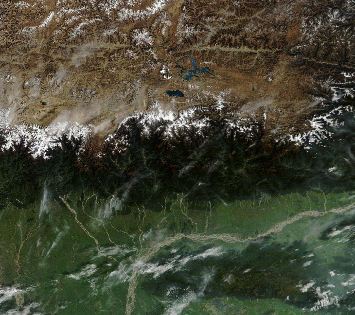
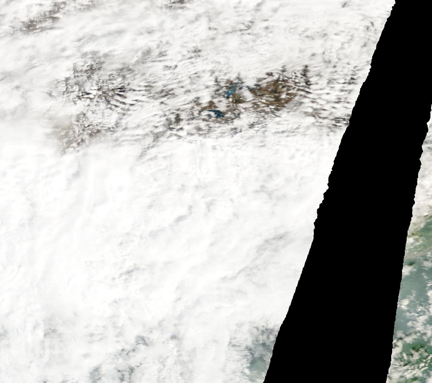
Drag to wipe. Same layer, same box, same satellite. Cloud 0.9% before, 72.2% after.
What the eye would see from orbit. Cloud is white, forest dark green, silt-laden floodwater pale brown. Printed here in black and white.
Cloud and snow are not separated. Both are bright and colourless at this resolution and there is no honest way to tell them apart from colour alone, so the figure this page prints is “cloud or snow” and means exactly that.
250 m per pixel. That is enough to show a changed river course, a flood plain and a large landslide scar. It is not enough to show a bridge or a building, and this page does not claim it is.
Frame 24.91–30.11°N, 87.499–93.361°E. The region reported, not a located site.
Open the live comparison Zoom, re-date, or switch to radar.
NASA Worldview Snapshots. Public domain, courtesy of NASA EOSDIS GIBS.
It has happened before
4 comparable events, with what each one actually cost. Every toll below is an official or peer-reviewed count, not a headline.
What happened in each, and what was learned
- South Lhonak Lake, Sikkim · 3–4 October 2023
- South Lhonak Lake, Sikkim. 14.7 million m³ of frozen moraine collapsed into the lake, raising a wave around 20 m high that breached the dam and released some 50 million m³ of water. It destroyed the 1,200 MW Teesta-III dam at Chungthang and travelled 385 km down the Teesta into Bangladesh, damaging about 25,900 buildings and 31 major bridges. There was no functioning early warning system; what warning reached people came informally from border police upstream.
- Chorabari Lake, above Kedarnath · 16–17 June 2013
- Chorabari Lake above Kedarnath, Uttarakhand, overtopped its moraine and drained in five to ten minutes — the second phase of the disaster, after a rainfall-driven debris flow the day before. A genuine lake outburst, though the lake was rain-fed rather than glacier-fed.
- Dig Tsho, Nepal · 4 August 1985
- Dig Tsho, Nepal. An ice avalanche into the lake overtopped and cut the end moraine; six to ten million m³ drained in about four hours, destroying a nearly-complete hydro plant 11 km downstream and 14 bridges. It struck during a lull in the trekking season.
- Chamoli, Uttarakhand — and not a GLOF · 7 February 2021
- Chamoli, Uttarakhand — commonly filed as a glacial lake outburst and not one. About 27 million m³ of rock and glacier ice fell from Ronti Peak and became a debris flow. No lake was involved; the peer-reviewed account was written specifically to correct the early reporting.
What these counts leave out
- Lakes below the monitoring threshold. CWC monitors above 10 hectares; the July 2025 Rasuwa flood came from a supraglacial lake in Tibet that had not been noticed at all.
- Anything upstream of the border. India has no gauge above the Tibetan frontier on the Brahmaputra system, and Nepal's Bhote Koshi warning system has a lead time of about six minutes because its sensors are all on the Nepali side of a catchment that begins in Tibet.
- The distinction between hazard types, in early reporting. Rock-ice avalanches, landslide-dam breaks and true lake outbursts are routinely reported as one another in the first days, and the correction usually arrives months later in a journal.
The alarm for India
Nepal is not somebody else’s disaster. The triggers differ; the vulnerability is the same, and it is already measured.
Confirmed India impact
No named source has reported an Indian casualty or evacuation figure.
What is already counted above India
The corridors this maps onto
Downstream of this event: Bihar and eastern Uttar Pradesh on the Koshi and Gandak; Assam and north Bengal on the Brahmaputra and Teesta. The Koshi basin is 2.6% of the Himalaya's southern slope and has produced 51.6% of its recorded glacial lake outbursts.
This column is exposure, not an outcome. Nothing in it is a report that anything has happened in India. It is where the same hazard would arrive.
What happens next
Two horizons. A level only where a published threshold and a number exist to put something against — everything else is named as a watch, not graded.
Next 24–72 hours
Coming days and weeks
The rainfall level is computed from a forecast model over a representative point — Open-Meteo forecast API, not a gauge at the event. The ungraded items are the mechanisms that follow this hazard. This page does not pretend to know their probability.
Data and sources
Everything this page is built from, counted by kind. Nothing here is quoted in this site’s own voice.
View all 27 sources
Reported
- Glacial lake outburst in Bhutan triggers flood alert in northern West Bengal, Assam The Hindu · Fri, 30 Oct 2026 03:56:56 GMT
- Glacial lake outburst in Bhutan: North Bengal on red alert as flood threat looms; thousands evacuated The Times of India · Fri, 30 Oct 2026 03:11:00 GMT
- Glacial lake outburst in Bhutan: What it is and why it threatens India India Today · Thu, 29 Oct 2026 18:34:42 GMT
- Bhutan glacial lake outburst flood triggers alert in North Bengal; thousands relocated, disaster response The Economic Times · Fri, 30 Oct 2026 03:21:47 GMT
- Glacial Lake Outburst In Bhutan Sends Flash Floods Warning To Bengal, Assam NDTV · Fri, 30 Oct 2026 01:47:27 GMT
- Bhutan glacial lake outburst triggers flash flood alerts across Assam and West Bengal The Week · Fri, 30 Oct 2026 04:37:25 GMT
- Bhutan Glacial lake burst triggers flood scare in India, 10,000 evacuated Punjab Newsline · Fri, 30 Oct 2026 07:09:09 GMT
- Bengal, Assam on high flood alert after glacial lake bursts in Bhutan The Indian Express · Fri, 30 Oct 2026 03:13:33 GMT
- Glacial lake bursts in Bhutan: Flash flood hits Gasa district, high alert in Bengal and Assam Business Today · Fri, 30 Oct 2026 06:23:08 GMT
- Bhutan Glacial Lake Burst Puts Bengal, Assam on High Flood Alert; Over 10,000 Evacuated NorthEast India24 · Fri, 30 Oct 2026 08:12:29 GMT
- Bhutan glacial lake outburst flood triggers flash flood alert in West Bengal and Assam; Gasa Hot Spring washed away Organiser · Fri, 30 Oct 2026 05:30:52 GMT
- Bhutan lake outburst puts villages in Bengal, Assam on flood watch Firstpost · Fri, 30 Oct 2026 01:48:27 GMT
- Bhutan Glacial Lake Outburst Triggers Flash Flood Alerts In West Bengal And Assam Swarajya · Fri, 30 Oct 2026 03:08:50 GMT
- West Bengal, Assam on flood alert after Bhutan glacial lake outburst Hindustan Times · Fri, 30 Oct 2026 02:12:10 GMT
- Glacial Lake outburst in Bhutan triggers flood warnings in West Bengal, Assam Connected to India · Fri, 30 Oct 2026 03:53:34 GMT
- Bhutan GLOF sparks flood alert in Bengal, Assam; authorities on high vigilance National Herald · Fri, 30 Oct 2026 04:43:31 GMT
- India issues flood advisory for West Bengal and Assam after Bhutan's Shintaphu glacial lake outburst WION · Fri, 30 Oct 2026 03:44:00 GMT
- Himalayan GLOF Scare: Bhutan Glacial Lake Burst Triggers Flood Warning In Assam, West Bengal On High Alert News18 · Thu, 29 Oct 2026 20:12:00 GMT
- Glacial lake flood in Bhutan disrupts traffic, prompts evacuations in India Deshsanchar · Fri, 30 Oct 2026 03:51:48 GMT
- Bhutan Glacial Lake Outburst Triggers Flash Flood, Over 10,000 Evacuated In North Bengal Outlook India · Fri, 30 Oct 2026 04:25:15 GMT
- Bhutan glacial lake burst triggers flood alert in north Bengal, residents evacuated The Hawk · Fri, 30 Oct 2026 09:09:46 GMT
- Bhutan glacial lake outburst triggers flash flood alerts in Bengal, Assam The Hawk · Fri, 30 Oct 2026 03:50:27 GMT
- Bhutan glacial lake outburst forces over 10,000 to safety in Bengal; Assam on flood alert NewsDrum · Fri, 30 Oct 2026 03:28:33 GMT
- Bhutan Glacial Lake Outburst Flood Triggers High Alert In Assam, West Bengal Border Districts On Watch ABP Live English · Fri, 30 Oct 2026 01:39:29 GMT
- Over 10,000 Evacuated in West Bengal as Bhutan Glacial Lake Outburst Triggers Flood Alert Kashmir Life · Fri, 30 Oct 2026 08:58:30 GMT
- Bhutan glacial lake outburst puts Bengal and Assam on flood alert; over 10,000 evacuated Daily Pioneer · Fri, 30 Oct 2026 05:37:42 GMT
- Glacier lake bursts in Bhutan, threatening flash floods in Assam and Bengal; 15,000 people evacuated India.com · Fri, 30 Oct 2026 04:19:19 GMT
A headline is evidence that something was said. It is never evidence that it is true — which is why every figure at the top of this page carries the outlet that printed it and, where they disagree, all of them.
What is not established
- Casualty and damage figures are not established here. Any number in the headlines below belongs to the outlet that printed it.
- The mechanism is this page's reading of how the event was first reported, not a finding. Himalayan disasters are often reclassified once fieldwork is done.
- The extent of the affected area has not been verified against satellite or official mapping.
- Downstream consequences for India are a known mechanism for this hazard, not a confirmed outcome of this event.
Last changed 14:39 IST, 30 Oct 2026.
This is one event
The standing picture — how much extreme rain India actually gets, what IMD counts as extreme, who the rain kills, and what is changing across twelve cities — is on the situation page this belongs to.
A gap is a gap
An empty day stays empty — a gap in the record is a gap in the record, never a zero.
Cite this page
Reuse freely — CC BY 4.0. Every figure carries its source and its cadence in how the number is made. If you quote a number from here, quote the kind with it. Each upstream source keeps its own terms.
This is what we are doing.
It is not enough.
The work against this reading
Mostly the written record, and going to look. Three of the essays on this site were reported out of flood years, and Gram Anubhav takes groups into villages living with this, run with over a hundred grassroots partners in the villages themselves.
And why it is not a reply
Publishing and going to see are not resilience. Swechha does not build drainage, and nothing here reduces the 3,594 deaths this page counts. What the work does is make the count harder to ignore — a smaller claim than it sounds, and the only one the evidence supports.
Understand the data
- What counts as extreme rainfall?IMD's day categories — and the reason a day is the wrong unit for a cloudburst.
- How is Delhi's rainfall measured?Gauges, a seasonal normal, and why two Delhi rainfall figures rarely agree.
- Measured or modelled?The first question to ask of any environmental number, and the one most often skipped.
Once a month, what these numbers did.
One email. What the six readings did that month, what moved and what did not, and what we did about it. Nothing else, ever — no appeals between digests, and your address is never shared with anybody.
Confirm by email before anything is stored. Every message carries a one-click link to stop them.