
Active situation
Assam flood
Four readings this page holds, and where each one is explained. Every source behind them.
What is a flood, really
Not too much water. Too little room for it.
Think of the drain on your street. Somebody sized it for the rain they expected. Now give it three times that rain, and half fill it with silt and plastic first.
A river works the same way, only bigger. It has a channel, and beside the channel a floodplain — flat land that is supposed to get wet. That is the river's spare room.
Build on the spare room and the water still arrives. It just arrives somewhere that now has houses on it.
Global heating — heating, not warming — loads the dice: a hotter atmosphere carries more moisture, so when it rains, it rains harder.
Where
Assam — and the river it runs into. Positions are real coordinates; the extent of the event is not known.
Region named in the reportingDownstream, in the pathThe satellite frame
Frame 674 km wide. The ring is an area, not a point: the reporting names the region, not a location inside it. Positions of the downstream places are true.
- Origin Assam
- Direct impact India, downstream
What caused it
Candidate mechanisms, each with the evidence word it has actually earned and, where one exists, the counted thing that makes it plausible. Nothing on this list is established for this event.
How would we know?
- Extreme rainfall
- India Meteorological Department daily rainfall for the district against its own heavy (64.5 mm) and very heavy (115.5 mm) day categories.
- Reservoir or barrage release
- The operator's own gate-operation log and the Central Water Commission's downstream gauge record for the same hours.
- Embankment or drain failure
- A state irrigation department breach report, which names the location and the length.
- Drainage that could not carry it
- Whether the same streets flood at the same rainfall every year, which is a records question rather than a hydrology one.
What the satellite sees
Imagery published here, not linked to. The same public NASA layers a newsroom would use, over the region the reporting names, on the dates either side of the event.

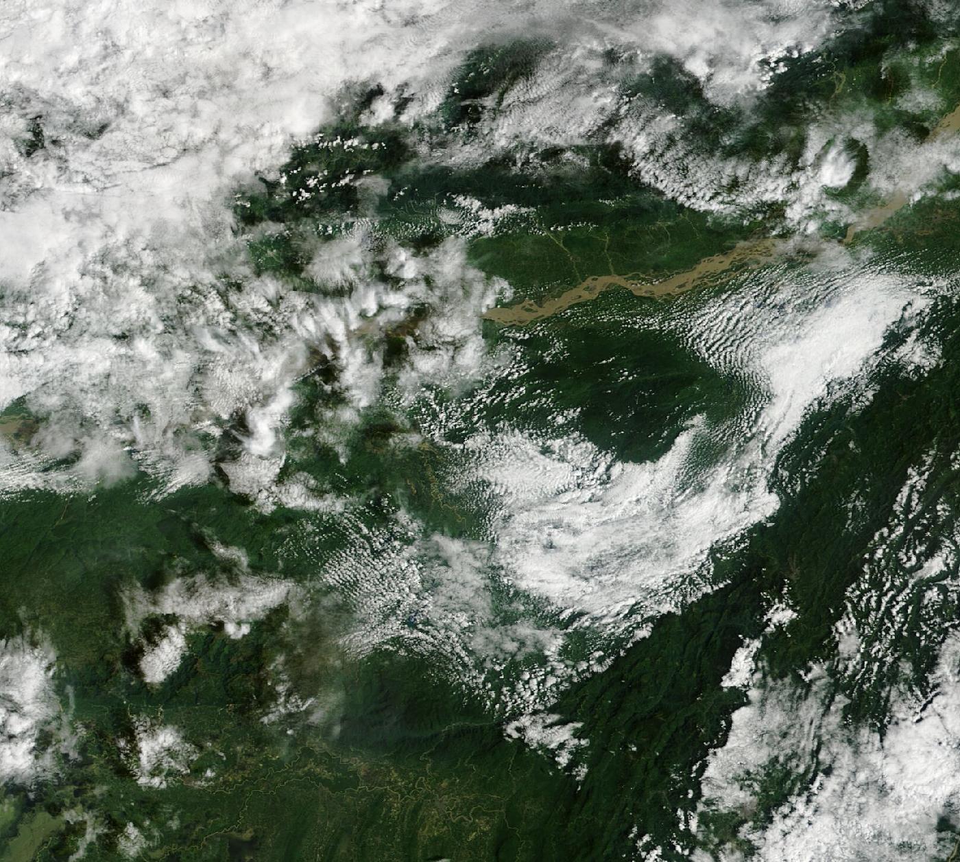
The two frames come from different instruments — true colour, second satellite before, true colour after — because nothing else could see the ground on both dates. They are shown side by side rather than as a slider: sliding between two instruments shows the instrument changing.
What the eye would see from orbit. Cloud is white, forest dark green, silt-laden floodwater pale brown. Printed here in black and white.
Cloud and snow are not separated. Both are bright and colourless at this resolution and there is no honest way to tell them apart from colour alone, so the figure this page prints is “cloud or snow” and means exactly that.
250 m per pixel. That is enough to show a changed river course, a flood plain and a large landslide scar. It is not enough to show a bridge or a building, and this page does not claim it is.
Frame 24.6–27.8°N, 91.157–94.723°E. The region reported, not a located site.
Open the live comparison Zoom, re-date, or switch to radar.
NASA Worldview Snapshots. Public domain, courtesy of NASA EOSDIS GIBS.
It has happened before
3 comparable events, with what each one actually cost. Every toll below is an official or peer-reviewed count, not a headline.
What happened in each, and what was learned
- CWC changes what it counts · 2023
- The reporting basis changed. From this year CWC's column counts deaths AND missing persons on the wider MHA 'floods and heavy rains' definition, and moves bridge, dam and road damage outside the headline total — so 2023 and 2024 cannot be compared with earlier years.
- Yamuna at Delhi, highest ever recorded · 13 July 2023
- The Yamuna reached 208.66 m at Delhi's Old Railway Bridge, passing the 207.49 m of September 1978 — the highest level ever recorded there.
- The deadliest flood year on record · 1977
- The deadliest flood year in the seventy-two-year record, and the reason the long-run average sits near 1,700 deaths a year.
What these counts leave out
- Whatever a state chose not to report. For 2024 Assam filed 'Not Reported' against crop value, house value, public utilities and total damage — while reporting 1.39 million ha affected and 110 deaths. A dozen other states did the same, so the published national total is a floor, not an estimate.
- Embankment failures and breaches. A 2025 parliamentary answer states this is not maintained centrally at all.
- Infrastructure, in the headline figure. From 2023 damage to bridges, dams, roads and irrigation sits outside the published total — in 2024 that excluded ₹10,447 crore, more than the entire reported total.
- Urban flooding as a distinct category. There is no national dataset separating it from riverine flooding.
What happens next
Two horizons. A level only where a published threshold and a number exist to put something against — everything else is named as a watch, not graded.
Next 24–72 hours
Coming days and weeks
The rainfall level is computed from a forecast model over a representative point — Open-Meteo forecast API, not a gauge at the event. The ungraded items are the mechanisms that follow this hazard. This page does not pretend to know their probability.
Data and sources
Everything this page is built from, counted by kind. Nothing here is quoted in this site’s own voice.
View all 1 sources
Reported
- ‘Come out of your ego boat’: Akhil Gogoi appeals to Assam CM over flood probe India Today NE · Sun, 11 Oct 2026 07:39:07 GMT
A headline is evidence that something was said. It is never evidence that it is true — which is why every figure at the top of this page carries the outlet that printed it and, where they disagree, all of them.
What is not established
- Casualty and damage figures are not established here. Any number in the headlines below belongs to the outlet that printed it.
- The mechanism is this page's reading of how the event was first reported, not a finding. Himalayan disasters are often reclassified once fieldwork is done.
- The extent of the affected area has not been verified against satellite or official mapping.
- Whether this event is continuing or has passed is not established.
Last changed 13:09 IST, 11 Oct 2026.
This is one event
The standing picture — how much extreme rain India actually gets, what IMD counts as extreme, who the rain kills, and what is changing across twelve cities — is on the situation page this belongs to.
A gap is a gap
An empty day stays empty — a gap in the record is a gap in the record, never a zero.
Cite this page
Reuse freely — CC BY 4.0. Every figure carries its source and its cadence in how the number is made. If you quote a number from here, quote the kind with it. Each upstream source keeps its own terms.
This is what we are doing.
It is not enough.
The work against this reading
Mostly the written record, and going to look. Three of the essays on this site were reported out of flood years, and Gram Anubhav takes groups into villages living with this, run with over a hundred grassroots partners in the villages themselves.
And why it is not a reply
Publishing and going to see are not resilience. Swechha does not build drainage, and nothing here reduces the 3,594 deaths this page counts. What the work does is make the count harder to ignore — a smaller claim than it sounds, and the only one the evidence supports.
Understand the data
- What counts as extreme rainfall?IMD's day categories — and the reason a day is the wrong unit for a cloudburst.
- How is Delhi's rainfall measured?Gauges, a seasonal normal, and why two Delhi rainfall figures rarely agree.
- Measured or modelled?The first question to ask of any environmental number, and the one most often skipped.
Once a month, what these numbers did.
One email. What the six readings did that month, what moved and what did not, and what we did about it. Nothing else, ever — no appeals between digests, and your address is never shared with anybody.
Confirm by email before anything is stored. Every message carries a one-click link to stop them.